The Course of Meteorological Instrumentation and Observations


25 Slides2.11 MB
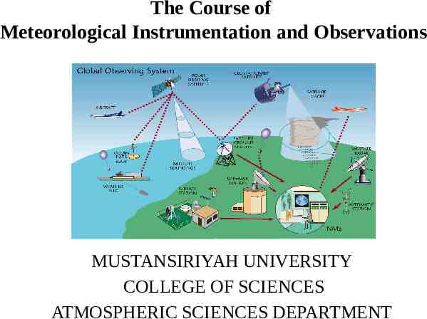
The Course of Meteorological Instrumentation and Observations MUSTANSIRIYAH UNIVERSITY COLLEGE OF SCIENCES ATMOSPHERIC SCIENCES DEPARTMENT
Welcome Students! TO LECTURE FIVE CLOUDS
A cloud is a visible collection of billions of small water and/or ice particles suspended in the atmosphere above Earth’s surface. Clouds form when water vapor condenses. Clouds come in all shapes and colors, and exist at all levels of the troposphere. Their unique features can tell us something about the atmospheric processes that led to their formation, or indicate impending weather changes.
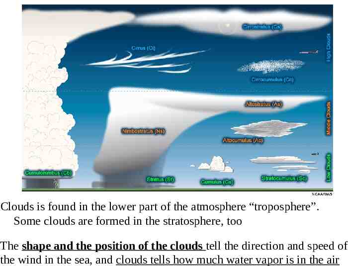
Clouds is found in the lower part of the atmosphere “troposphere”. Some clouds are formed in the stratosphere, too The shape and the position of the clouds tell the direction and speed of the wind in the sea, and clouds tells how much water vapor is in the air
CLASSIFICATION OF CLOUDS The French naturalist Lamarck (1744–1829) proposed the first system for classifying clouds in 1802; however, his work did not receive wide acclaim. One year later, Luke Howard, an English naturalist, developed a cloud classification system that found general acceptance. In essence, Howard’s innovative system employed Latin words to describe clouds as they appear to a ground observer. In Howard’s system, there were the four basic cloud forms. Other clouds could be described by combining the basic types. For example, nimbostratus is a rain cloud that shows layering, whereas cumulonimbus is a rain cloud having pronounced vertical development.
In 1887, Abercromby and Hildebrandsson expanded Howard’s original system and published a classification system that, with only slight modification, is still used today. Ten principal cloud forms are divided into four primary cloud groups. Each group is identified by the height of the cloud’s base above the surface: high clouds, middle clouds, and low clouds. The fourth group contains clouds showing more vertical than horizontal development. Within each group, cloud types are identified by their appearance. The table below lists these four groups and their cloud types.
Approximate Height of Cloud Bases above the Surface for Various Locations Clouds can be categorized based on other factors such as altitude, composition, and temperature (see table below).
Cloud Altitude Observations Because the troposphere is much warmer in the tropics than at higher latitudes, the cloud base height differs for mid and high clouds across these regions. For instance, mid-level clouds near the equator generally have heights between 2 km and 7.5 km, while closer to the poles, these cloud heights are likely to be in 2-4 km range.
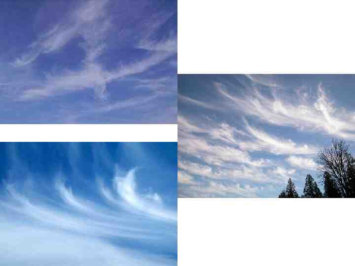
Cloud Identification High clouds in middle and low latitudes generally form above 6000 m. Because the air at these elevations is quite cold and “dry,” high clouds are composed almost exclusively of ice crystals and are also rather thin. High clouds usually appear white, except near sunrise and sunset, when the unscattered (red, orange, and yellow) components of sunlight are reflected from the underside of the clouds. The most common high clouds are the Cirrus (Ci), which are thin, wispy clouds blown by high winds into long streamers called mares’ tails. They can look like a white, feathery patch with a faint wisp of a tail at one end. Cirrus clouds usually move across the sky from west to east, indicating the prevailing winds at their elevation. They predict fair to pleasant weather.
Cirrocumulus clouds (Cc), seen less frequently than cirrus, appear as small, rounded, white puffs that may occur individually, or in long rows. When in rows, the cirrocumulus cloud has a rippling appearance that distinguishes it from the silky look of the cirrus and the sheet like cirrostratus. Cirrocumulus seldom cover more than a small portion of the sky. The dappled cloud elements that reflect the red or yellow light of a setting sun make this one of the most beautiful of all clouds. The small ripples in the cirrocumulus strongly resemble the scales of a fish; hence, the expression “mackerel sky” commonly describes a sky full of cirrocumulus clouds.
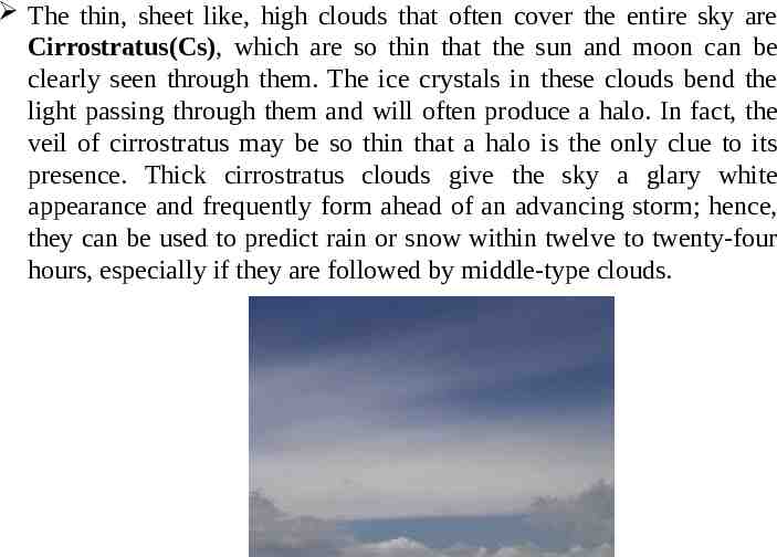
The thin, sheet like, high clouds that often cover the entire sky are Cirrostratus(Cs), which are so thin that the sun and moon can be clearly seen through them. The ice crystals in these clouds bend the light passing through them and will often produce a halo. In fact, the veil of cirrostratus may be so thin that a halo is the only clue to its presence. Thick cirrostratus clouds give the sky a glary white appearance and frequently form ahead of an advancing storm; hence, they can be used to predict rain or snow within twelve to twenty-four hours, especially if they are followed by middle-type clouds.
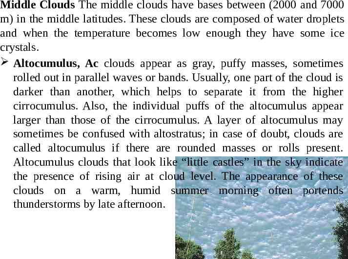
Middle Clouds The middle clouds have bases between (2000 and 7000 m) in the middle latitudes. These clouds are composed of water droplets and when the temperature becomes low enough they have some ice crystals. Altocumulus, Ac clouds appear as gray, puffy masses, sometimes rolled out in parallel waves or bands. Usually, one part of the cloud is darker than another, which helps to separate it from the higher cirrocumulus. Also, the individual puffs of the altocumulus appear larger than those of the cirrocumulus. A layer of altocumulus may sometimes be confused with altostratus; in case of doubt, clouds are called altocumulus if there are rounded masses or rolls present. Altocumulus clouds that look like “little castles” in the sky indicate the presence of rising air at cloud level. The appearance of these clouds on a warm, humid summer morning often portends thunderstorms by late afternoon.
The Altostratus, As, is a gray or blue-gray cloud that often covers the entire sky over an area that extends over many hundreds of square kilometers. In the thinner section of the cloud, the sun (or moon) may be dimly visible as a round disk, which is sometimes referred to as a “watery sun”. Thick cirrostratus clouds are occasionally confused with thin altostratus clouds. The gray color, height, and dimness of the sun are good clues to identifying an altostratus. The fact that halos only occur with cirriform clouds also helps one distinguish them. Another way to separate the two is to look at the ground for shadows. If there are none, it is a good bet that the cloud is altostratus because cirrostratus are usually transparent enough to produce them. Altostratus clouds often form ahead of storms having widespread and relatively continuous precipitation. If precipitation falls from an altostratus, its base usually lowers. If the precipitation reaches the ground, the cloud is then classified as nimbostratus.
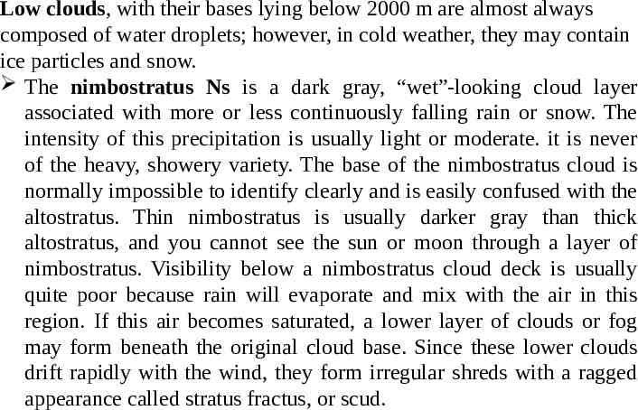
Low clouds, with their bases lying below 2000 m are almost always composed of water droplets; however, in cold weather, they may contain ice particles and snow. The nimbostratus Ns is a dark gray, “wet”-looking cloud layer associated with more or less continuously falling rain or snow. The intensity of this precipitation is usually light or moderate. it is never of the heavy, showery variety. The base of the nimbostratus cloud is normally impossible to identify clearly and is easily confused with the altostratus. Thin nimbostratus is usually darker gray than thick altostratus, and you cannot see the sun or moon through a layer of nimbostratus. Visibility below a nimbostratus cloud deck is usually quite poor because rain will evaporate and mix with the air in this region. If this air becomes saturated, a lower layer of clouds or fog may form beneath the original cloud base. Since these lower clouds drift rapidly with the wind, they form irregular shreds with a ragged appearance called stratus fractus, or scud.
A low, lumpy cloud layer is the stratocumulus, Sc. It appears in rows, in patches, or as rounded masses with blue sky visible between the individual cloud elements. Often they appear near sunset as the spreading remains of a much larger cumulus cloud. The color of stratocumulus ranges from light to dark gray. It differs from altocumulus in that it has a lower base and larger individual cloud elements. Rain or snow rarely fall from stratocumulus. Notice that the rounded masses are larger than those of the altocumulus.
Stratus St is a uniform grayish cloud that often covers the entire sky. It resembles a fog that does not reach the ground. Actually, when a thick fog “lifts,” the resulting cloud is a deck of low stratus. Normally, no precipitation falls from the stratus, but sometimes it is accompanied by a light mist or drizzle. This cloud commonly occurs over Pacific and Atlantic coastal waters in summer. A thick layer of stratus might be confused with nimbostratus, but the distinction between them can be made by observing the base of the cloud. Often, stratus has a more uniform base than does nimbostratus. Also, a deck of stratus may be confused with a layer of altostratus. However, if you remember that stratus clouds are lower and darker gray, the distinction can be made. can be seen early in the morning or late in afternoon
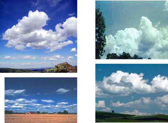
Clouds with large vertical extending The puffy Cumulus, Cu cloud takes on a variety of shapes, but most often it looks like a piece of floating cotton with sharp outlines and a flat base. The base appears white to light gray. The top of the cloud often in the form of rounded towers denotes the limit of rising air and is usually not very high. These clouds can be distinguished from stratocumulus by the fact that cumulus clouds are separated (usually a great deal of blue sky between each cloud) whereas stratocumulus usually occur in groups or patches. Also, the cumulus has a dome or tower shaped top as opposed to the generally flat tops of the stratocumulus. Cumulus clouds that show only slight vertical growth are associated with fair weather; therefore, we call these clouds “fair weather cumulus.”
If the cumulus clouds are small and appear as broken fragments of a cloud with ragged edges, they are called cumulus fractus. Harmlesslooking cumulus often develop on warm summer mornings and, by afternoon, become much larger and more vertically developed. When the growing cumulus resembles a head of cauliflower, it becomes a towering cumulus. Most often, it is a single large cloud, but, occasionally, several grow into each other, forming a line of towering clouds. Precipitation that falls from them is always showery.
If they continues to grow vertically, it develops into a giant cumulonimbus, a thunderstorm cloud. Its top may extend upward to the tropopause. A cumulonimbus can occur as an isolated cloud or as part of a line or “wall” of clouds. Massive amounts of energy are released by the condensation of water vapor within a cumulonimbus and result in the development of violent up- and downdrafts, which may exceed fifty knots. fast winds at these higher altitudes can reshape the top of the cloud into a huge flattened anvil. These great thunderheads may contain all forms of precipitation—large raindrops, snowflakes, snow pellets, and sometimes hailstones—all of which can fall to earth in the form of heavy showers. Lightning, thunder, and even violent tornadoes are associated with the cumulonimbus.
Other appearances Kelvin-Helmholtz Wave lightning halo aurora borealis sun dog rainbow haze dawn