Sequence Stratigraphy of Miocene Mixed CarbonateSiliciclastic in


6 Slides4.36 MB
Sequence Stratigraphy of Miocene Mixed CarbonateSiliciclastic in Fold and Thrust Belt System, Banggai Basin Firman Herdiansyah 1, M Burhannudinnur 2, Suryo Prakoso 3, Isranto HP 4, Dwi Kurnianto 5, Teddy Irano 6, Billy Harnest 7 1,2 Department of Geological Engineering, Faculty of Earth and Energy Technology, Universitas Trisakti Jakarta, Jakarta, Indonesia 3 Department of Petroleum Engineering, Faculty of Earth and Energy Technology, Universitas Trisakti Jakarta, Jakarta, Indonesia 4,5 Badan Afiliasi Teknologi Mineral, Universitas Trisakti 6,7 Exploration, JOB Pertamina-Medco E&P Tomori Sulawesi, Jakarta, Indonesia
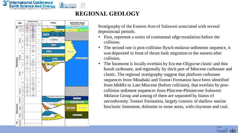
REGIONAL GEOLOGY Stratigraphy of the Eastern Arm of Sulawesi associated with several depositional periods. First, represent a series of continental edge translation before the collision. The second one is post-collision flysch-molasse sediments sequence, it was deposited in front of thrust fault migration to the eastern after collision. The basement is locally overlain by Eocene-Oligocne clastic and thin basalt carbonate, and regionally by thick part of Miocene carbonate and clastic. The regional stratigraphy suggest that platform carbonate sequences from Minahaki and Tomori Formation have been identified from Middle to Late Miocene (before collision), that overlain by postcollision sediment sequences from Pliocene-Pleistocene Sulawesi Molasse Group and among of them are separated by hiatus of unconformity. Tomori Formation, largely consists of shallow marine bioclastic limestone, dolomite in some areas, with claystone and coal.
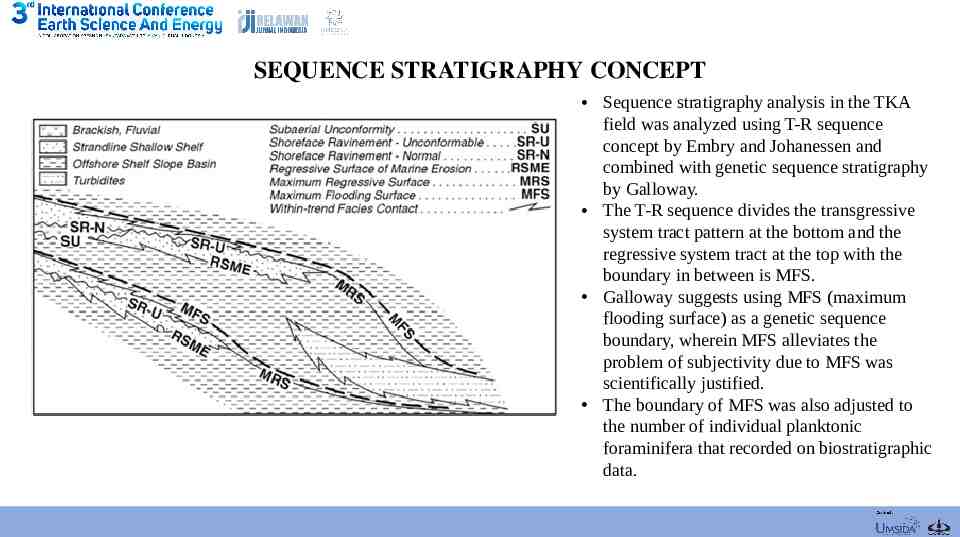
SEQUENCE STRATIGRAPHY CONCEPT Sequence stratigraphy analysis in the TKA field was analyzed using T-R sequence concept by Embry and Johanessen and combined with genetic sequence stratigraphy by Galloway. The T-R sequence divides the transgressive system tract pattern at the bottom and the regressive system tract at the top with the boundary in between is MFS. Galloway suggests using MFS (maximum flooding surface) as a genetic sequence boundary, wherein MFS alleviates the problem of subjectivity due to MFS was scientifically justified. The boundary of MFS was also adjusted to the number of individual planktonic foraminifera that recorded on biostratigraphic data.
DATA & METHOD The data was used for stratigraphic analysis in the TKA Field is geophysical well log correlation data, core, biostratigraphic data. TKA field composed 3 wells has micropaleontological data, based on those wells can be identified foraminiferal and calcareous nannoplankton zonation. The analysis is intended for interpretation of the lithofacies, sequence stratigraphy, facies association and stratigraphic correlations. The sequence stratigraphy analysis was determined several sequence boundaries start from the 2nd order using the Trangressive-Regressive cycle. Furthermore, the identifying of system tract either 3 rd and 4th order.
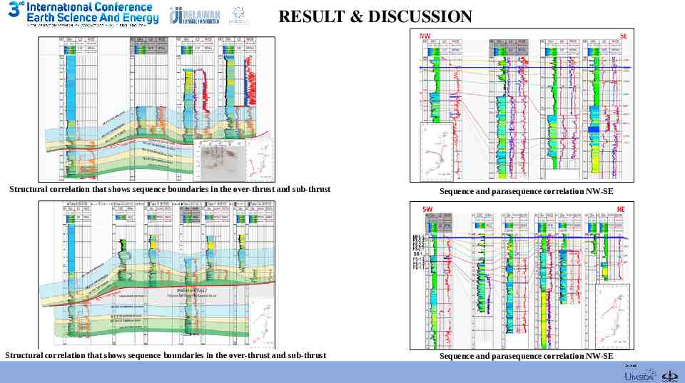
RESULT & DISCUSSION Structural correlation that shows sequence boundaries in the over-thrust and sub-thrust Structural correlation that shows sequence boundaries in the over-thrust and sub-thrust Sequence and parasequence correlation NW-SE Sequence and parasequence correlation NW-SE
CONCLUSION 1. Sequence stratigraphy was analyze using geophysical well log correlation data, core, and biostratigraphic data. TKA field composed 3 wells has micropaleontological data, based on those wells can be identified foraminiferal and calcareous nannoplankton zonation. The maximum flooding surface (MFS) characterized by high specimen abundance of planktonic foraminifera and calcareous nannoplankton. Meanwhile, sequence boundary (SB) characterized by reduce level of abundance specimen. 2. The T-R cycle 2nd order reveal that regressive phase from Tomori limestone to Matindok clastic, and transgressive phase start from top Matindok clastic to the shallow shelf Minahaki Limestone, and back to regressive phase from top shallow shelf Minahaki Limestone to Celebes Mollase. 3. Based on structural correlation with northeast-southwestward, west-eastward, and northwest-southeastward that shows the direction of strike from thrust fault with north-south trend. The thinning layer occurs due to imbricate thrust fault that recorded at well TKAB. 4. Parasequence boundary is FS (flooding surface). Where, flooding surface is the upper boundary of highstand system tract that shows the carbonate growth or sediment supply higher than increasing relative sea level. The authors wish to thank JOB Pertamina-Medco-Tomori Sulawesi for contribute this research, and special thanks to Badan Afiliasi Teknologi Mineral Universitas (BATM) Universitas Trisakti to funded several laboratories.